Looking back on the season
From Fina to Maila, the 2025-26 tropical cyclone season was a busy 6 months for many teams at the Bureau.
Forecasting and warning for tropical cyclones is a major task that not one person or team can do alone.
Our teams work closely together during all severe weather events. Together, we aim to keep the Australian community safe and informed when it matters most.
Start of a cyclone's journey
All tropical cyclones begin as tropical lows. Not all tropical lows will become cyclones.
For a cyclone to form, a tropical low must move over warm tropical waters, which act as fuel for the system. Under the right conditions, this weather can start to spin and become organised.
Once our Tropical Cyclone team identifies a potential tropical low, they will issue it onto our 7 day tropical cyclone forecast.
"If we think there is more than a 5 per cent chance of a tropical cyclone forming anywhere over the next week, we will start issuing forecasts," Tropical Cyclone Senior Meteorologist Joe Courtney said.
Our Hazard Preparedness and Response team consists of meteorologists, hydrologists and other experts. They work together to brief with emergency services.
We work with emergency services in the lead-up to and during cyclone season. Emergency services provide on-the-ground support for communities during severe weather. It is important to keep them informed every step of the way.
Communicating to the public
During periods of severe weather, we ramp up our communications through social media and the media.
Our Community Information team will do extra interviews, radio crosses and TV. These reach affected communities with the latest information.
Those from Western Australia or the Northern Territory may know Meteorologist Jessica Lingard. She is often on the radio or television giving weather updates.

Meteorologist Jessica Lingard with former ABC WA Afternoons host Michael Tetlow
During Severe Tropical Cyclone Narelle, Mrs Lingard did more radio crosses than usual. She spoke with ABC emergency broadcasting, and local and Indigenous media outlets.
"There is often an overwhelming amount of information available during events like this, which can make things even more stressful for those who may be impacted," Mrs Lingard said.
"My team and I take that overwhelming amount of information and break it down into bite-sized pieces that are easier to understand."
Talking to Territorians
When a cyclone is up to five days away from making landfall, Tropical Cyclone Watches and Warnings are issued.
"When we think there is a good chance of gale force winds hitting somewhere on the coast or islands in the next two days, we will start issuing a Tropical Cyclone Watch.
"When that risk is within the next day, we will start issuing a Tropical Cyclone Warning," Mr Courtney said.
We also increase briefings with emergency services and start press conferences.
Northern Territory Hazard Preparedness and Response Manager Shenagh Gamble works with emergency services all year. This helps them prepare for and respond to weather hazards.
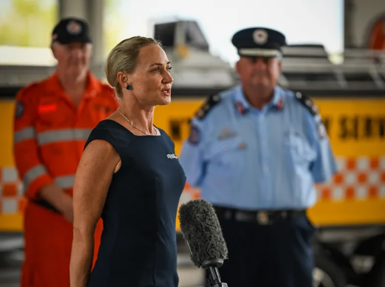
Northern Territory Hazard Preparedness Response Manager Shenagh Gamble at a press conference. Credit: Patch Clapp.
During Tropical Cyclone Fina, Ms Gamble spoke at several press conferences. Also speaking were the police and emergency services.
"The tropical cyclone's eye was going to pass around 50 km north of Darwin, bringing damaging winds, heavy rainfall and flash flooding to the Darwin region and surrounds."
Remote Indigenous communities in the Tiwi Islands and on North and South Goulburn Island were also in the path of the cyclone.
Auslan and Indigenous interpreters joined press conferences. They interpreted the information into Australian Sign Language, Tiwi and Maung languages.
"In a place like the Northern Territory, where communities are spread out and conditions can vary a lot from one area to another, that extra communication really makes a difference," Ms Gamble said.
After landfall
The community will feel the impacts most when a cyclone makes landfall. Strong winds, rain and flooding are among the key weather hazards.
Even as a cyclone weakens as it moves across land, the impacts can be long lasting and severe.
Queensland meteorologist Harry Clark said the biggest risk post-cyclone is flooding. This risk can continue for days or weeks.
"Over Christmas and New Year, a tropical low was moving through north-west Queensland, forecast to bring several hundred millimeters of rain in just a few days," he said.
"We knew that major flooding with significant impacts to livestock was likely."
Agricultural land and livestock were at risk during this event. Mr Clark ensured his messaging informed those in the affected region.
"Tailoring the messaging allowed for increased awareness of the risk in both the lead up and during the flooding event."
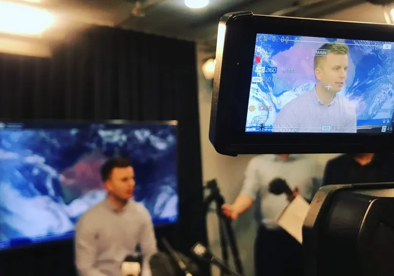
Meteorologist Harry Clark doing an interview for television
The Bureau also has a National Water Operations team. Their main role is to assess and warn for riverine flooding.
When a tropical low is identified by the Tropical Cyclone team, the Water Operations team begins identifying areas that may be at risk of flooding.
Flood Watches can be issued up to four days in advance of potential flooding. Flood Warnings are issued when flooding is likely or occurring.
"Floods can pose a significant risk to life and infrastructure, and the impacts can be devastating," acting National Water Operations Manager Christopher Kenyon said.
"It is important to warn for floods to ensure the community and emergency services have as much time as possible to prepare for impacts."
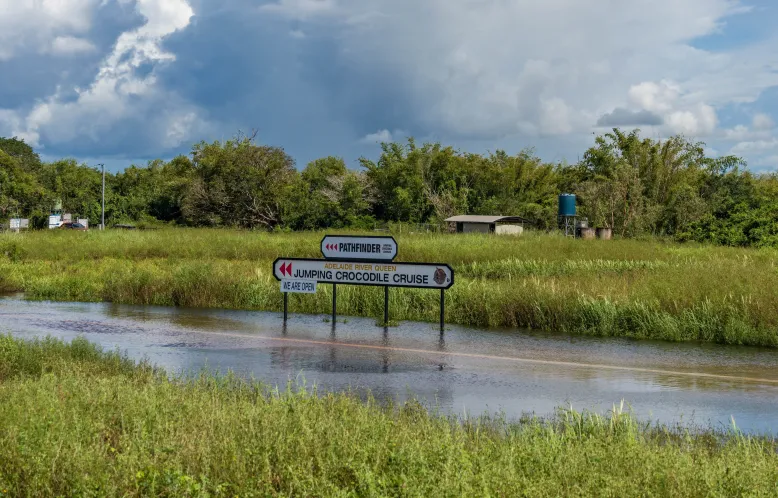
Flooding along the Adelaide River in the Northern Territory. Credit: Patch Clapp.
Preparing for the next cyclone season
The past season saw many tropical lows and tropical cyclones. These all tracked and impacted differently.
For Joe Courtney and the Tropical Cyclone team, the break between seasons is a time to learn from the last season and prepare for the next one.
"Most of the cyclones behaved like we thought they would, but a few times they did some unexpected things," Mr Courtney said.
"While this is the beauty of nature, it also challenges us to reflect and adjust future forecasts to ensure people are adequately prepared."
As we approach the next cyclone season, the Bureau will start working with communities, businesses and local emergency services to raise awareness of cyclones and their impacts.
We will also use these next few months to reflect on the recent season. This helps us to improve our ways of working and the services we deliver to the Australian community.


