At a glance
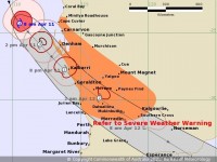
- Tropical Cyclone Seroja continues to move towards the west coast and is expected to cross the coast as a Category 2 system on Sunday evening.
- People in the Shark Bay area can expect to experience the impact of the system from early afternoon Sunday.
- People in the Kalbarri and Geraldton area can expect to feel the impact of the system from mid to late afternoon on Sunday.
- Wind gusts of up to to 150 km/hr are expected as the cyclone moves across coastal areas. Gusts to 125 km/h may extend inland and as far as the northern wheat belt (equivalent to a rare intense winter storm); winds up to 150 km/h can may cause damage to homes, sheds and significant damage to caravans, trees and increase the risk of power failure.
- Gusts to 100 km/h are likely through to Esperance - refer Severe Weather Warning
- Abnormally high tides and large waves could cause minor inundation along the coast between Carnarvon and Lancelin, increasing to serious flooding in the Denham and Shark Bay region and possibly near Kalbarri.
- Tropical Cyclone Seroja will be moving very quickly (around 50 kilometres per hour) as it makes landfall, and weather conditions will deteriorate rapidly with the worst conditions at any one location are expected to last around 3 hours, with the areas at greatest risk from Denham to Geraldton.
- Dangerous storm tides, which are above the highest annual high tide level and causing flooding of low-lying coastal areas, are possible through areas north of the cyclone's track, particularly in the Shark Bay and Kalbarri areas.
- TC Seroja's unusual trajectory so far south on the west coast poses a greater risk than usual due to communities being unfamiliar with the destructive force of a tropical cyclone.
TC Seroja
People on the coast between Carnarvon and Lancelin are warned that a period of dangerous weather will develop on Sunday afternoon and evening, and will extend inland across areas of the southern Gascoyne and wheat belt overnight. Coastal and island communities in the cyclone's path can expect a period of unusually high tides, destructive winds and intense rainfall.
Tropical Cyclone Seroja is expected to cross the coast as a Category 2 system on Sunday evening. The area at greatest risk is from Denham to Geraldton. Coastal communities and adjacent inland areas between Carnarvon and Lancelin are urged to monitor weather warnings on the Bureau's website and BOM Weather app, and be prepared to take action.
Destructive wind gusts of up to 150km/h are expected close to the centre of Tropical Cyclone Seroja as it crosses the coast. The most likely area to experience destructive wind gusts is on the coast from Denham to Geraldton. Wind gusts of this strength are very rare for the Central West coast. Winds up to 150 km/h can may cause damage to homes, sheds and significant damage to caravans, trees and increase the risk of power failure.
Tropical Cyclone Seroja will be moving very quickly (around 50 kilometres per hour) as it makes landfall, and weather conditions will deteriorate rapidly with the worst conditions at any one location are expected to last around 3 hours.
Abnormally high tides and large waves could cause minor inundation along the coast between Carnarvon and Lancelin, increasing to serious flooding in the Denham and Shark Bay region and possibly near Kalbarri.
After crossing the coast, Tropical Cyclone Seroja will bring brief periods of damaging wind gusts and heavy rain to inland areas through the southern Gascoyne, Wheat Belt, southern Goldfields and in areas around Esperance.
Flash flooding and strong winds are not expected in Perth and surrounding areas, however the area is likely to receive up to 50 mm of rain over Sunday and Monday
Stay up to date with all weather warnings and cyclone information on the Bureau's website http://www.bom.gov.au/wa/warnings/ and the BOM Weather app.?


